Take-off at
Lae, New Guinea
0000 GCT -- Time
Aloft 0 hr
Amelia
Earhart (AE) and Fred Noonan (FN) depart Lae, New
Guinea for Howland Island, 2,556 miles to the
east.
The Lockheed
Electra Model 10-E NR16020 is equipped with two Pratt
& Whitney R-1340 Wasp S3H1 engines capable of
developing a maximum of 650 hp at take-off, with a
fuel consumption rate of 95.3 gph total. The plane is loaded with 1,100
gallons of fuel.
FN's flight
plan included a headwind estimate of 15 mph. The
flight takes up a true heading of 083o on a
direct course to Howland.
Begin Cruise-Climb
0005 GCT -- Time
Aloft 0.08 hr
Fuel
consumed at take-off 8 gallons, 1,092 gallons
remaining. AE throttles back to a cruise-climb power setting that
consumes 50 gph at an airspeed of 115 mph and a
sustained rate-of-climb of 250 fpm.{9}
With the
estimated headwind of 15 mph, the Electra would
make good a groundspeed of 100 mph while climbing.
Level at 8,000
0037 GCT -- Time
Aloft 0.62 hr
Flight reaches cruise altitude
of 8,000 feet. Distance from Lae 62 miles, with
2,494 miles to go on the 083o course direct
to Howland.
Total fuel consumed in climb 35
gallons, 1,065 gallons remaining. AE
levels off and increases airspeed to FN's planned
157 mph consuming 50 gph.{9}
With the
estimated headwind of 15 mph, the Electra would
make good a groundspeed of 142 mph in level
flight.
Abeam Nukumanu
0708 GCT -- Time
Aloft 7.13 hr
AE maintains airspeed at FN's
planned 157 mph, consuming 50 gph.
Flight flies abeam north of the
island of Nukumanu at 8,000 feet. Distance
from Lae 850 miles, with 1,706 miles to go on the 083o course direct
to Howland. Position report was logged late,
at 0718 GCT. Report included measured headwind
of 26.5 mph. {1}
With the
measured headwind of 26.5 mph, the Electra makes
good a groundspeed of 130.5 mph in level
flight. Total fuel consumed at abeam
Nukumanu 361 gallons, 739 gallons
remaining.{9}
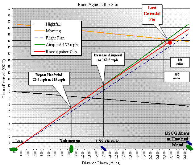
Overhead USS
Ontario
1034 GCT -- Time
Aloft 10.57 hr
Distance from Lae 1,300 miles,
with 1,256 miles to go on the 083o course direct
to Howland.
AE repeated attempts to contact USS Ontario
200 miles ahead were all in vain.
FN becomes concerned about whether
RDF will be operative to support gathering range {7},
calls for increase in airspeed to conserve celestial
navigation distance at night and to shorten dead
reckoning distance following sunrise and to reduce
steering errors after Last
Celestial Fix.{0}
AE increases airspeed to 168.5 mph,
consuming 59.3 gph. Total fuel consumed at this
location 528 gallons, 572 gallons
remaining.{9}
Last Celestial Fix
1737 GCT -- Time
Aloft 17.61 hr
Total fuel consumed at this
location 946 gallons, 154 gallons remaining.
FN takes Last Celestial Fix as
flight approaches the beginning of Nautical
Twilight.{2}
Distance from Lae 2,300 miles, with
256 miles to go on the 083o course direct
to Howland. With the
measured headwind of 26.5 mph, the Electra made
good a groundspeed of 142 mph between USS Ontario
and Last Celestial Fix.
AE reduces power for descent at 500
feet per minute, maintaining 168.5 mph and consuming
23 gph.{9}
|
Landfall
Offset Procedure -- at the Last
Celestial Fix,
FN calls for heading change from 083o to 067o, which is an offset to the left
side of direct course, thereby [a] compensating
for maximum dead reckoning errors to
Howland of plus or minus 16o and [b] selecting the shorter
distance to 157-337 LOP.
{3}
|
Level at 1,000
1751 GCT -- Time
Aloft 17.84 hr
Total fuel consumed at this
location following descent 951 gallons, 149
gallons remaining.{9}
With the
headwind of 26.5 mph at 8,000 ft, the Electra was
making good a worst-case groundspeed of 142 mph in
level flight. Headwind naturally slows with
decreasing altitude to 15 mph at 1,000 ft
following the descent.{0}
AE sets up level flight at reduced
power to extend endurance aloft, using 30 gph for
120 mph airspeed.{9}
Alternative #1
Actual steering error turns out to be 16o to the right of heading, equal to
the allowance by the Landfall Offset Procedure
selected at Last
Celestial Fix. The Electra is delivered
directly to Howland Island.
2003
GCT -- Time Aloft 20.05 hr
Total fuel consumed on arrival
overhead Howland Island, 1,024, landing with 76
gallons in reserve, 2:30 search time available.
Note: The
flight would have already arrived at Howland before
the Last Transmission by Amelia Earhart at
2013 GCT. Inasmuch as the landing
did not take place, Alternative #1 must be rejected.
Alternative #2 Actual
steering error turns out to be 0o, which is 16o
to
the left of direct course
to Howland as established by the Landfall
Offset Procedure at Last
Celestial Fix. The Electra intercepts
the 157-337 LOP with 71 miles to go
after the right turn to Howland Island.
2033 GCT -- Time
Aloft 20.55 hr
Inasmuch
as the flight reaches the landfall turning point on
157-337 LOP 71 miles north of Howland, only 2
minutes of flying time are required to reach the
visibility limit of 47 miles from Howland at 1,000
ft AGL.
Note:
Radio failures mean that no RDF gathering range is
established.{7}
Total fuel consumed on arrival
overhead Howland, 1,039, landing with 61 gallons
in reserve, 2:02 search time available. The flight would have reached
157-337 LOP and turned south 17 minutes before
the Last Transmission by Amelia Earhart, after
which only 5 minutes are required to reach
visibility limit.
Note: Since the arrival did
not take place, Alternative #2 must be rejected.
Alternative #3 Actual
steering error turns out to be 16o
to
the left of heading, which
is beyond the allowance in the
Landfall Offset Procedure selected
at Last
Celestial Fix. The Electra
is delivered to the
157-337 LOP
with 142 miles to go after the right turn to
Howland.
2015 GCT -- Time
Aloft 21.25 hr
With the
flight reaching the landfall turning point on
157-337 LOP 142 miles north of Howland, a total of
48 minutes of flying time would be required to reach
the visibility limit of 47 miles.
Note:
Radio failures mean that no RDF gathering range is
established.{7}
If the flight were to continue
south, the total fuel consumed on arrival overhead
Howland would be 1,060, landing with 40 gallons
in reserve, 1:20 search time available.
Note: Since safe arrival was
quite possible, Alternative #3 must be considered.
Alternative #3 Last
Transmission by Amelia Earhart
2013 GCT -- Time
Aloft 20.22 hr
The
flight would have already flown 11 minutes on a
heading of 157o toward the south at the
time of the Last Transmission by Amelia Earhart,
thus the Electra was at a position at most 120 miles
north of Howland on the 157-337 LOP.
Between 2013 GCT
and 2113 GCT -- unable to see Howland, AE
decides that FN's offset to the north and thus that
turn to the south at the 157-337 LOP was the
wrong landfall procedure to use. AE reverses
course to a heading of 337o. {0}
That assumption complies with
all the known conditions, including the profile of
radio receptions from the Electra transcribed onboard
Itasca.{6}
Ironic
Duplication of
Conditions:
The analysis in {7} refers to an
incident that occurred
nearly a month earlier,
on June 8, 1937.
AE and FN crossed the
Atlantic Ocean
eastbound, with Dakar as
the destination.
FN had to use dead
reckoning for that leg,
which covered 1,400
miles from
Natal to Dakar.
He chose a heading north
of Dakar, applying a
landfall navigation
procedure with an offset
of 4o. Upon
arrival at the African
coastline, the Electra
was supposed to turn
right and fly south
to the airfield at
Dakar. AE did not
believe that procedure
to be correct. Exercising
her
prerogative as
pilot in
command, she
turned left
and flew along
the coastline
searching for
the
destination at
Dakar.
Fortunately,
there was an
airport in
French West
Africa 120
miles north
of Dakar.
As
shown in this
analysis,
conditions
approaching
Dakar were
nearly the
same while
approaching
Howland a
month later:
[1]
requirement
for dead
reckoning (but
hoping for
RDF);
[2]
application of
landfall
navigating
procedure
(with the 157-337
LOP in
place of an
actual
coastline);
[3] FN's
prescribed
offset of the
Electra's
course
toward
the north by
16o
{0},
which allows
for imprecision
in the Last Celestial Fix as
the 'point of
departure'
(unlike the
beginning of
the Atlantic
crossing,
which departed
from an
aerodrome);
[4] AE's
rejection of
the turn
toward the
south in
favor of
taking a
heading
to the north
(or AE's
reversal of
course after
not seeing
destination
from cockpit
while facing
south); and
[5] conducting
final search
away from the
destination on
Howland
Island.
Unfortunately,
there was not
an alternate
airfield --
only
the
Pacific Ocean
-- along the 157-337 LOP toward
the north.
The
puzzles in the Amelianna
Collection do not
make use of information from
flights prior to July 2,
1937.
|
|
Fuel Exhaustion
2248 GCT -- Time
Aloft 22.81 hr
Most
likely location of the ditching is between 234 and
334 miles north of Howland Island on a heading of 337o from Howland Island.
End-of-Flight
Summary (as depicted in the sketch below)...
At 2002 GCT, AE turns southeast
(heading 157) and flies for 11 minutes before making the
last transmission at 2013 GCT. Perhaps as much as
an hour later, without receiving radio contact from Itasca
and not seeing Howland, AE concludes that FN's
offset-north landfall navigating was wrong. AE
turns northwest (heading 337), away from Howland and Itasca.
In Simplexity
Aloft AE's 2013 GCT transmission is described as
"An ambiguous -- indeed, an impossible --
flight maneuver and altogether useless for guiding
subsequent searches."
Based on the logic in
the analysis set forth above, your
immediate answer to the question, "Which
way, Amelia?"
must be "South." Some
time later, your answer must be "North."
|
Some authors (and I) have
speculated that the last line in Amelia Earhart's last
radio transmission was transcribed in error -- that she
really said...
WE ARE RUNNING ON LINE NORTH NOT
SOUTH.
|
 The analysis set
forth below applies information developed throughout
this series of 10 puzzles. The links indicated in
{braces} correspond...
The analysis set
forth below applies information developed throughout
this series of 10 puzzles. The links indicated in
{braces} correspond... 