|
Copyright ©2010 by Paul Niquette. All rights reserved. |
||
The familiar word altitude in the aviation lexicon represents the instantaneous elevation of the aircraft itself above sea level, measured in feet. In nautical parlance, where the vessel itself is confined to one altitude -- sea level -- the word altitude indicates the elevation of a celestial body as it appears above the horizon, measured in degrees, minutes, and seconds.Here is another statement of the obvious: At a given instant in time, from any location on the surface of the earth, every object in the sky will appear at some angle above the horizon. That's its altitude for that time and location. At the subpoint for a given object, of course, its altitude is 90 degrees. Elsewhere, that object would be seen at -- well, a different altitude. Here is the key to celestial navigation: At a given instant in time, every object in the sky appears at the same altitude for a set of locations that form a circle on the surface of the earth. The circle is called line of position (LOP), which is named for the celestial object and for that instant in time. Inasmuch as the earth is quite a big place, when a segment of a LOP is plotted on a local navigation chart, it looks like a straight line.
To "shoot" one star or planet was not enough to determine a fix for the vessel's location. The navigator needed to obtain at least two LOPs, preferably intersecting at a near right angle -- and taken hurriedly to be as close to the same instant in time as possible. Alas, celestial navigation has always been fraught with errors. Moreover, way-finding from one fix to another required dead reckoning, itself error-prone. Common principles of navigation -- imperfections included -- apply to avigation. Inevitably, errors suffered in the sky are much larger than those experienced on the surface of the sea, as aircraft are so much faster than ocean-going vessels. 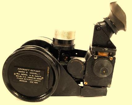 Gary LaPook has served
as an invaluable consultant for many aspects of this
series of puzzles. He is arguably the world's
leading authority on celestial navigation in general and
on Amelia Earhart's round-the-world flight in
particular. LaPook's website
entitled "Fred Noonan and Amelia Earhart plus General
Flight Navigation" contains an immense body of reference
materials, including contemporaneous manuals, plus
expert commentaries on many aviation topics, with an
emphasis on celestial navigation -- its methods, its
limitations, and its instruments. Gary LaPook has served
as an invaluable consultant for many aspects of this
series of puzzles. He is arguably the world's
leading authority on celestial navigation in general and
on Amelia Earhart's round-the-world flight in
particular. LaPook's website
entitled "Fred Noonan and Amelia Earhart plus General
Flight Navigation" contains an immense body of reference
materials, including contemporaneous manuals, plus
expert commentaries on many aviation topics, with an
emphasis on celestial navigation -- its methods, its
limitations, and its instruments.
The photograph on the right was provided by Gary LaPook. It shows a Mark 3 Octant, like the one used by Fred Noonan, navigator for the 1937 round-the-world flight of Amelia Earhart.
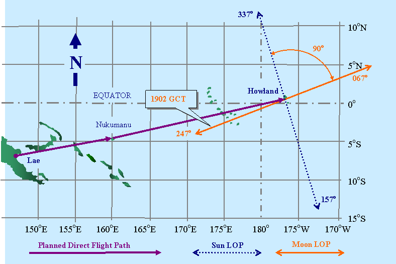
Here is yet another statement of the obvious: No object in the sky appears exactly overhead of a fixed location (subpoint) for more than an instant in time. Well, almost obvious. Polaris is an exception. So too are geostationary communications satellites, come to think of it. In general, though, no LOP is stationary. Noonan's 157-337 sun LOP would be present at that location only at a certain instant in time -- the planned arrival time (1800 GCT). At that instant, the sun's altitude would be 6 degrees all along the 157-337 LOP passing over Howland Island.
In the figure above, solvers will see that the sun was not "the one and only celestial body in the sky" that morning. The previous sentence deserves exclamatory punctuation and so does the next one. The moon, which was in its last quarter, was also available to Fred Noonan for celestial navigation. Not only that, but the moon's LOP for 1902 GCT offered reciprocal headings of 067-247 degrees -- closely aligned with the course line (072) for the flight.Sophisticated solvers ought to be justified in concluding that by taking sightings of the moon, world renowned celestial navigator Fred Noonan would have been able to correct for lateral errors in navigating (see Live Reckoning and Wages of Flight) and thereby assure success for the flight. Amelia Earhart, with or without radio direction finding (see Simplexity Aloft), would thus fly the Lockheed Electra directly to Howland Island and land with plenty of fuel in reserve. Accordingly, we have a mystery to solve...
|
||
| Gary LaPook learned to fly in 1970 and has been an airline transport pilot since 1978. In the 1970s he ferried new airplanes from the factory to aircraft dealers, including crossing the Atlantic using celestial navigation to find the Azores. He started sailing in the 1960s and always brings his sextant along. He occasionally takes his sextants flying and shoots sights just to stay in practice. |
 Let us
begin with a statement of the obvious: At any given instant in time,
every object in the sky appears exactly overhead
at some point on the surface of the earth. It's called the subpoint for
that object.
That applies to all celestial bodies -- stars and
planets, sun and moon. Of course, the earth is
busy rotating on its axis and orbiting the sun driving
distant stars across the firmament. The planets
("wandering stars" Greek 1640) meander all over the
night sky, while the moon makes its monthly orbit of
the earth. Thus every subpoint traces an
earthly pathway, unique and predictable.
Let us
begin with a statement of the obvious: At any given instant in time,
every object in the sky appears exactly overhead
at some point on the surface of the earth. It's called the subpoint for
that object.
That applies to all celestial bodies -- stars and
planets, sun and moon. Of course, the earth is
busy rotating on its axis and orbiting the sun driving
distant stars across the firmament. The planets
("wandering stars" Greek 1640) meander all over the
night sky, while the moon makes its monthly orbit of
the earth. Thus every subpoint traces an
earthly pathway, unique and predictable.