|
Copyright ©2010 by Paul Niquette. All rights reserved. |
|||
Solvers of the Simplexity
Aloft puzzle studied two modes of RDF, Simplex
and Half-Duplex, then identified ten critical issues
in Phase 3, which, acting together,
resulted in the utter failure of RDF -- both modes --
which doomed the flight. In this puzzle
solvers are invited to consider that Amelia Earhart
and Fred Noonan would not have known that
radio direction finding was indeed failing in Phase
3 of the Lae-to-Howland segment.
Until it was too late.
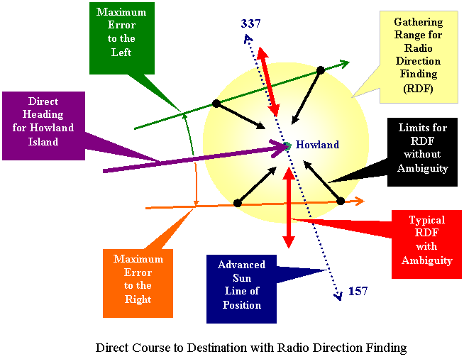
There were always two positions of the loop antenna that produced a null, one pointed toward the radio station, while the other pointed 180 degrees away from the radio station. The two null points were potentially confusing. Some historians are troubled by that simple limitation existing in RDF technologies vintage 1937, conjecturing that it might have become critical. Indeed, for simplex RDF, it would be necessary for Amelia Earhart to resolve the ambiguity, and to do that, she must know the general direction of the transmitter. Ironically, selection of the appropriate bearing is made easy when the flight is known to be approaching the station from far enough away. For homing, the pilot merely selects the bearing angle closer to the present heading and turns the aircraft so as to reduce the bearing angle to zero. Incidentally, half-duplex RDF suffers from the same ambiguity. The loop antenna on Howland Island and the one on board Itasca would each have two nulls. Accordingly, for resolution, radio operators would need to know the direction from which the aircraft is approaching.
Success in Phase 3 definitely required functioning RDF equipment and trained people plus getting the Lockheed Electra inside that gathering range.
{a} Offset the aircraft's heading to one side,Having done all three of those things... |
|||
In the final stages of the search
for Howland, the Electra was flying in clear skies
at 1,000 feet scanning the horizon for
Itasca with a smoke stack of, say, 40 feet above
the waterline.
|
 Solvers
of
the
Solvers
of
the 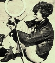 Purdue
University sponsored Amelia Earhart's flight
around the world ostensibly as a "flying
laboratory." This photograph features
the loop antenna that was mounted atop the
Lockheed Electra 10E and configured with the
Bendix RA-1 Manual Dirction Finder for
evaluation. The loop was controlled by
Earhart with a wheel inside the cockpit.
After tuning in and identifying a station on
the ground, the antenna was turned to detect a
'null', which indicated the 'bearing angle' to
the station.
Purdue
University sponsored Amelia Earhart's flight
around the world ostensibly as a "flying
laboratory." This photograph features
the loop antenna that was mounted atop the
Lockheed Electra 10E and configured with the
Bendix RA-1 Manual Dirction Finder for
evaluation. The loop was controlled by
Earhart with a wheel inside the cockpit.
After tuning in and identifying a station on
the ground, the antenna was turned to detect a
'null', which indicated the 'bearing angle' to
the station.