|
Copyright ©2009 by Paul Niquette. All rights reserved. |
|
  Flight,
like almost everything else one might name, has been
changed forever by GPS.
Solvers
will remember earlier challenges in navigating, whether
on city streets or country roads or in trackless
forests. They are all now made into trivial exercises by
GPS. Flight,
like almost everything else one might name, has been
changed forever by GPS.
Solvers
will remember earlier challenges in navigating, whether
on city streets or country roads or in trackless
forests. They are all now made into trivial exercises by
GPS.
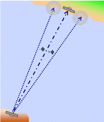
Here is a puzzle we will use to introduce an essential navigation concept for solving the most famous mystery in aviation history (see Which Way, Amelia?) Depicted in the diagram is the schematic of the plan for a flight by dead reckoning from an airport in the south across a large body water for a landing at an airport located close to the coastline. A point-to-point course line has been drawn. Diverging lines indicate the maximum expected navigational errors attributable to crosswinds aloft and to steering errors. Also shown are the limits of visibility
expected as the aircraft reaches the shoreline.
If the intended course is maintained, all will be well
and good. Near the extremes in navigational
errors, however, the airport may not be visible.
The pilot must decide which way to turn. A wrong
decision will cost extra flying time and fuel -- if
indeed there is enough fuel remaining after the
crossing for traipsing up and down the coast looking
for the airport.
|