Gathering Range

Copyright ©2010 by Paul Niquette. All rights reserved.
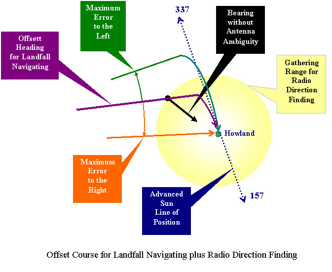
The diagram below is schematic in nature, such that all distances are left unspecified.  It depicts a realistic case pertinent to the final phase of the Lae-to-Howland flight.   An offset heading has been prescribed by Fred Noonan to the left of course as a conventional strategy for mitigating navigation errors. 
  • The offset direction (left) was chosen to intercept the closer arm of the 157/337 LOP.
  • The offset angle would be chosen to assure that the maximum navigational error to the right brings the Electra directly into the gathering range at Howland, wherein RDF homing in cooperation with Itasca would become functional. 

The most extreme navigation error to the left is shown missing the gathering range.  However, upon reaching the sun line-of-position, Amelia Earhart would be advised by Fred Noonan to turn with confidence to the right and onto a course of 157 degrees.   The expectation -- indeed, as it turned out, only the hope -- would be that eventually the Electra would come within gathering range and successfully complete the flight using RDF.

Solvers will observe that even with perfectly functional RDF equipment and people for both modes of RDF, Amelia Earhart and Fred Noonan would be deprived of advanced knowledge that RDF will be operable upon arrival -- that outside the gathering range, whether RDF will ever become operable would not be known. 

Solvers of Wages of Flight will be keenly aware that while approaching Howland Island, the Electra was getting low on fuel.  The offset for landfall navigating, of course, exacerbates the need for endurance aloft.  The plane would be slowed to extend time aloft, but that also puts final maneuvers into slow motion and increases psychological pressures on the two aviators who have already been flying for more than 20 hours and would now be earnestly gazing at the Pacific waters ahead looking for any sign of Howland or the Itasca.

For our solution, then, we offer the following answers to the question in the puzzle:

"What could possibly go wrong?"

1.  Fred Noonan offsets the heading to the north.  By happenstance, cumulative navigation errors turn out to be near the extreme left of the direct course (green line), taking the flight outside the gathering range.  At the ETA for the 157/337 LOP, Noonan calls for a turn toward the south onto a heading of 157 degrees. 

2  After some -- substantial -- period of time Amelia Earhart concludes that the flight should be inside the gathering range, but gets no joy on the radio.  Both Fred Noonan and Amelia Earhart are unaware that, because of multiple critical issues, no gathering range exists at Howland Island.

3. Amelia Earhart concludes that Fred Noonan's landfall offset was to the wrong side -- that the gathering range and Howland lies to the north.  As pilot-in-command, Amelia Earhart decides to  reverse direction to 337 degrees and flies toward the north, away from Howland until fuel exhaustion.


As we know now, RDF did not work for the flight.  In the final stages of the search for Howland, the Electra was flying in clear skies at 1,000 feet, scanning the horizon for Itasca with a smoke stack of, say, 40 feet above the waterline.  The visibility limit was 47 miles using this formula...

Visibility Limit = (2 R h1 + h12)1/2 + (2 R h2 + h22)1/2, where…
     R = radius of the earth,
     h1 = altitude of the Electra, and
     h2 = height of Itasca. 


Rejection by Earhart of Noonan's final heading is controversial.  But not unprecedented... 

Nearly a month earlier, on June 8, 1937, Amelia Earhart's round-the-world flight crossed the Atlantic Ocean, departing Natal at the eastern tip of Brazil, with Dakar at the tip of the Cape Verde Peninsula as its destination.  The Bendix RDF on board the Electra was known not to be working, so Fred Noonan had to rely on sun-shots and dead reckoning for navigation, using the drift meter for cross-course corrections. 

Noonan offset the prescribed heading 4o to the left of the direct course from Natal to Dakar, a distance of 1,400 miles.  At that distance, the nominal landfall intersection with the coast of Africa would be displaced less than 100 miles.  Upon arrival over the coast of Africa, landfall navigation called for a turn to the south.  However, not able to confirm charted objects on the coast-line, Earhart decided to turn north instead.

Long described the result this way (p.143)...

"As it turned out, it was the wrong direction but the right decision." 

In 20 minutes, they landed -- not at Dakar -- but at St. Louis in French West Africa, 120 miles north of Dakar.  No such outcome was possible on July 2, 1937.

The puzzles in the Amelianna Collection do not make use of information from flights prior to July 2, 1937. 


Home Page
Puzzle Page
Puzzles in the Skies
Amelianna Collection