|
Copyright ©2010 by Paul Niquette. All rights reserved. |
|||||
 The Shoot the Moon puzzle introduced the moon as
a celestial body in the sky over Howland Island on the
morning of July 2, 1937. Nota bene, the
availability of the moon for navigation by Fred Noonan
seems to have been utterly ignored by historians and
authors of Amelianna (see references).
Indeed, Long p.21
mentions the moon only as a visual aid for the
pilot. The Shoot the Moon puzzle introduced the moon as
a celestial body in the sky over Howland Island on the
morning of July 2, 1937. Nota bene, the
availability of the moon for navigation by Fred Noonan
seems to have been utterly ignored by historians and
authors of Amelianna (see references).
Indeed, Long p.21
mentions the moon only as a visual aid for the
pilot.
The diagram below reprises the sun LOP for the ETA (1800 GCT), with its reciprocal headings 157-337 degrees. Also shown are various moon LOPs in the vicinity of Howland with their respective times. For establishing the final course, the ideal moon LOP was 067-247 at 1902 GCT, nearly paralleling the course line of 072 degrees. Half an hour ealier, at 1839 GCT, the moon LOP made a cut at about 26 degrees to the course -- less than ideal, perhaps, but still better than nothing. According to Amelia Earhart's last radio transmission (see Simplexity Aloft), the flight had reached the 157-337 sun LOP some time before 2013 GCT. At that instant in time, the moon LOP would have made a cut at about 27 degrees to the course line, thus indicating which way to turn the aircraft to get onto the desired course.  One elementary if not obvious statement
seems appropriate for what we see in the diagram
above: For enroute celestial
navigating, two kinds of LOP are most useful: one
aligned with the course for adjusting heading and
the other perpendicular to the course for
establishing location along the course.
Fred Noonan was given both -- and not necessarily by
happenstance either. The moon LOP would have rescued
the flight from its failure in radio navigation, but
it was not applied, which challenges solvers for this
puzzle to answer the
question... What is your
explanation for why Fred Noonan did not
Shoot the Moon?
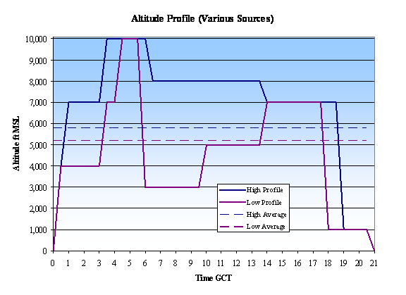
Here are three clues to consider. Clue #1 Solvers of The Clock Won't Wait will have taken note of following passage in Amelia Earhart's position report logged at 0718 GCT over the island of Nukumanu: "HEIGHT 8,000 FEET OVER CUMULUS CLOUDS..." Amelia Earhart and Fred Noonan were thus flying above the clouds at 0718 GCT. At that time, there were more than 1,850 miles to go. Nevertheless, it is not unreasonable to assume that cloudy skies continued in varying amounts toward the east. Indeed, the USCG cutter Itasca reported clouds to the north of Howland Island. That should be considered in conjunction with the most likely offset angle for Landfall Navigating toward the north.Clue #2 Solvers of Simplexity Aloft will have taken note of the following passage in one of Amelia Earhart's transmissions, which was logged on board Itasca at 1912 GCT: "WE ARE FLYING AT ALTITUDE 1000 FEET..." Exactly when the flight descended to 1,000 feet cannot be known. Solvers are invited to take a hint from the fact that for nearly an hour (57 minutes) before that transmission, Amelia Earhart maintained radio silence. It is reasonable to speculate that she was busy during that time flying on instruments in the clouds.Clue #3 Solvers of Gathering Range will have taken note that up to an hour before reaching the 157-337 LOP, Amelia Earhart could not have had any way of knowing that radio direction finding would be a total failure. Having a clear view of the moon might have been the only hope for the flight, but its critical value would not become apparent until it was too late. Amelia Earhart never stopped trying to get a bearing to Itasca, even changing RDF modes from simplex to half-duplex. After 20 hours aloft, fatigue surely played a role in the decisions made on board the Lockheed Electra at the end of that tragic flight. |
