|
Copyright ©2009 by Paul Niquette. All rights reserved. |
||
 From the preflight
information provided in the puzzle,
we learn the following: From the preflight
information provided in the puzzle,
we learn the following:
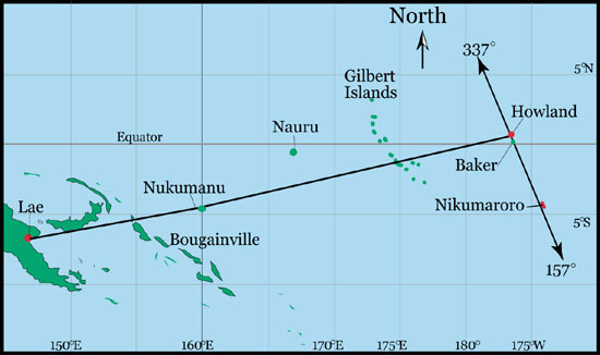
{1} Date of Flight ~~~~~~~~~~~~~~~~~~~~~~~~~~~ July 2, 1937From the map below, we are able to confirm geographical locations as follows:
{5} Lae ~~~~~~~~~ 6.733 S 147.000 E The Sunrise
and
Sunset Calculator offers four different kinds of
each, sunrise and sunset. Sophisticated solvers
will study the relevant definitions
and conclude that, for navigational purposes, the
demarcation between day and night of greatest concern to
Fred
Noonan would have been "Nautical" not "Official."
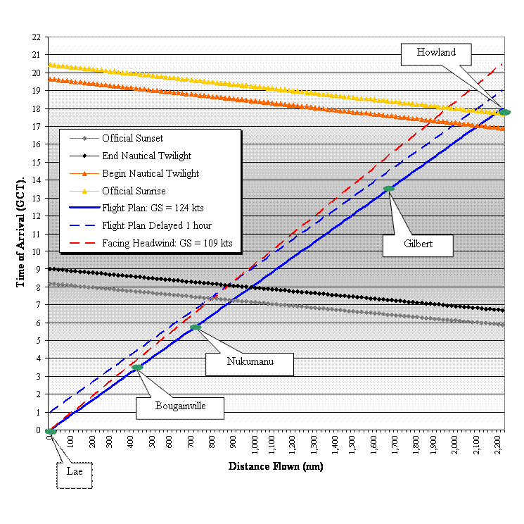
Consider first... {10} "Official Sunset" at Lae ~~~~~~~~~~~~~~~~~~~08:08 GCT...leaves more than three quarters of an hour of twilight during which star-sightingss would be doubtful for celestial navigation. This condition would prevail until... {11} "Nautical Sunset" at Lae (end of twilight) ~~~~~~ 08:57 GCTThus, nearly nine hours of daylight at Lae remained after take-off at 0000 GCT, during which navigation by dead reckoning would be allowed based on visual identification of landmarks, including, presumably one of the islands in the Bougainville chain. Using the calculator again we find... {12} "Nautical Sunset" at Bougainville ~~~~~~~~~~~~ 08:28 GCT...raising the question, Will the flight reach Bougainville before the sky goes dark there? -- in aviation parlance: "What is the ETA for Bougainville?" To answer questions like that, solvers must be able to figure out leg-distances and time-intervals. Here is one method for such estimations, starting with two reminders...
Between
Lae and Howland, the flight will make changes in
latitude and longitude of 7.535o and 36.366o,
respectively. Given those two geographcial
coordinates Fred Noonan would have applied spherical
trigonometry to calculate the great
circle distance from Lae to Howland. Purists
will object, of course, but for this puzzle, solvers can
simply use the Pythagorean
Theorem for a reasonable estimate of the angular
distance as 37.14o and compute an overall distance of 2,220 nm
or 2,556 statute miles (sm) for the historic leg.
From {3} we see that Noonan estimated a flying time of
18 hours, allowing us to estimate a ground
speed of 123.8 knots
(142.5 mph).
The distance from Lae to Bougainville as about 484 nm (557 sm) for an ETE and ETA of 3:55 GCT. According to {12}, that means about 4:23 of daylight to spare. Using the same method, we find that proceeding toward the east at 123.8 knots, the ETA for Nukumanu, 294 nm (339 sm) farther along from Bougainville, will be 6:17 GCT, where... {13} "Nautical Sunset" at Nukumanu ~~~~~~~~~~~ 08:10 GCT...affords almost two hours of daylight to spare for visual dead reckoning to that checkpoint. A visual confirmation of the flight's position overhead Nukumanu following dead reckoning for 2:22 with no ground references available, might have become crucial, inasmuch as Noonan planned to make a slight change in course there.
Upon arrival overhead one of the Gilbert islands at 13:45 GCT, the flight would find the islands in total darkness, inasmuch as... {14} "Nautical Sunset" at Gilbert ~~~~~~~~~~~~~~ 07:18 GCT...means that Noonan would have been depending on celestial navigation, taking star fixes, for some amount of time (see the graph below). Meanwhile... {15} "Nautical Sunrise" at Gilbert ~~~~~~~~~~~~~17:34 GCT...results in morning twilight that will end the darkness at Gilbert some time after the Electra has passed overhead (again, see the graph below). Of course, Noonan's main concern would have been... {16} "Nautical Sunrise" at Howland ~~~~~~~~~~~16:57 GCT...which precedes the planned ETA of 18:00 GCT by just over an hour. Morning twilight and sunrise would assure plenty of time "for a landing on an unlighted runway" as mentioned in the puzzle. Given... {17} "Official Sunrise" at Howland ~~~~~~~~~~~~17:46 GCT...the sun will have been above the horizon for 14 minutes before the ETA at Howland. Indeed, the sun would be 3.5o above the horizon as the Electra touched down. Accordingly, using just the pre-flight
planning information for solving the Here Comes the Sun question,
"Did Fred Noonan choose the appropriate take-off
time?" our answer is...
So, then, why that little "but" in the solution to the Here Comes the Sun puzzle?Delaying the arrival time at Howland also advances the transition from celestial navigation in the dark to dead reckoning in daylight, inasmuch as "Nautical Sunrise" would be relentlessly rushing westward toward the Electra at a relative ground speed of 1,180 mph (900 + 123.8 knots). Uh, oh.Noonan's last star-fixes must be completed farther away from Howland because of the headwind. Sophisticated solvers will surely enjoy determining exactly how much farther away -- and perhaps also generalizing the analysis to address any amount of flight delay. The graph below is a bit unusual, in that it shows time-related events as dependent variables plotted against fixed locations along the planned flight path. |